
As the idiomatic expression so aptly puts it, “A picture is worth a thousand words”. Or put another way, “Sometimes a visual presentation is far more descriptive than words”. After having read this entire account, I would challenge you to answer the following question: “Can you personally think of a single picture of Stone Harbor that you believe is worth a thousand words?”
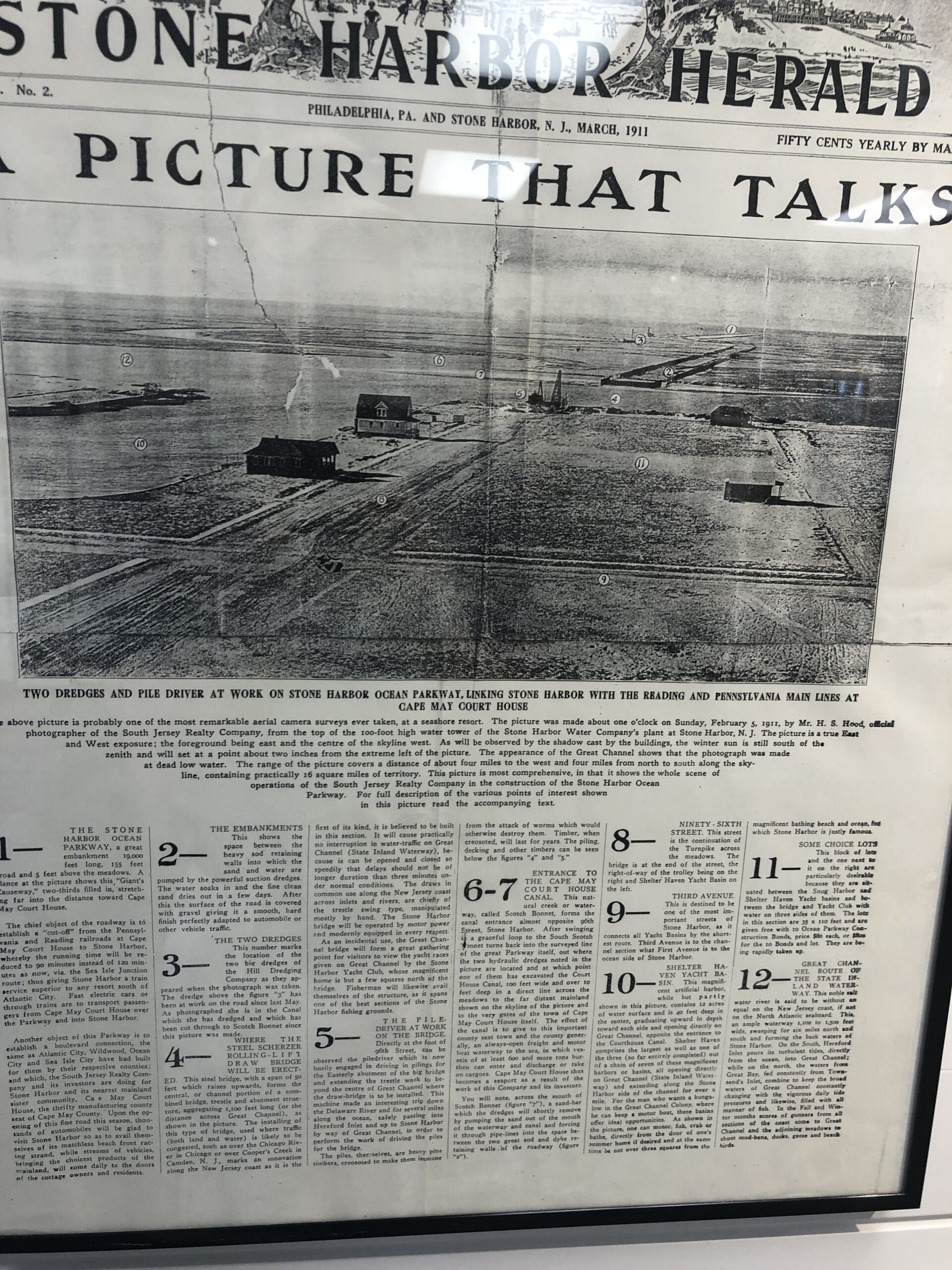
INTRODUCTION: Talk about making a very big splash! That’s exactly what we are presenting here. This expansive aerial photograph and written newspaper account shown above are currently framed and on display at the Stone Harbor Museum in Stone Harbor, New Jersey. This unusual and special photo taken in February of 1911 really captures the very beginnings of the resort we now call Stone Harbor. To facilitate making this account easy to read, I have re-typed every word that appears on the front page of the March 1911 edition of the “Stone Harbor Herald” publication.
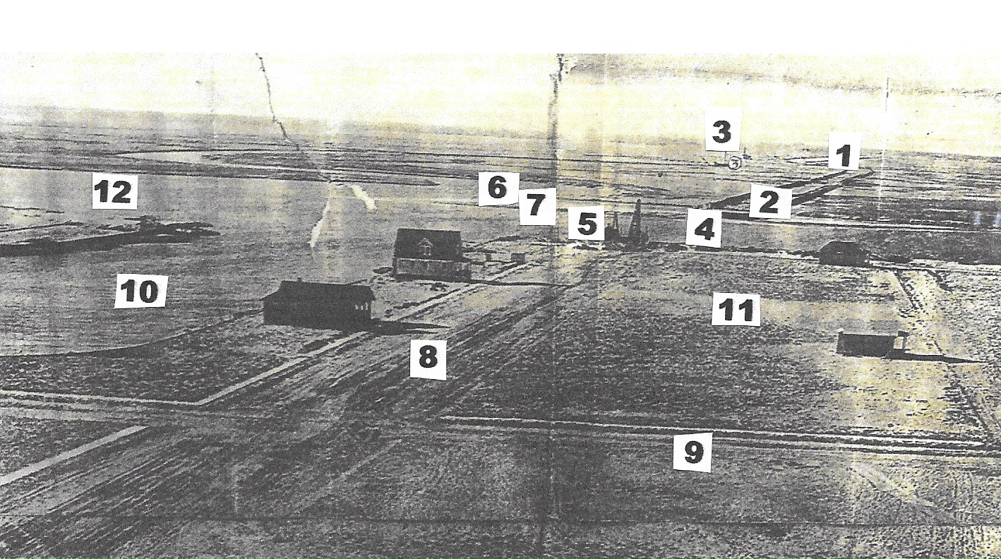
In addition, please know that I have also superimposed 12 different numbers onto the sweeping and far-reaching photo to serve as a means of reference for you. The text or the somewhat lengthy reading portion accompanying the photo presents 12 specific numbered descriptions that start with “1” and go to “12” corresponding to each of the 12 component areas shown in the image. That being said, a couple of non-Stone Harbor images, a post card and a photo, along with a few more Stone Harbor images will be presented as they have some bearing on supplemental information brought up and presented in the comprehensive article.
THE FEATURED PHOTOGRAPHIC IMAGE AND ARTICLE: Here is a reproduction of the exact words contained in our highlighted article starting with the masthead including edition and publication date, title and subtitle.
STONE HARBOR HERALD
Philadelphia, Pa. and Stone Harbor, N. J.
MARCH 1911
“A PICTURE THAT TALKS”
“TWO DREDGES AND PILE DRIVER AT WORK ON STONE HARBOR OCEAN PARKWAY, LINKING STONE HARBOR WITH THE READING AND PENNSYLVANIA MAIN LINES AT CAPE MAY COURT HOUSE”
“The above picture is probably one of the most remarkable aerial camera surveys ever taken, at a seashore resort. The picture was made about one o’clock on Sunday, February 5, 1911, by Mr. H. S Hood, official photographer of the South Jersey Realty Company, from the top of the 100-foot high water tower of the Stone Harbor Water Company’s plant at Stone Harbor, N. J. The picture is a true east and west exposure; the foreground being east and the centre of the skyline west. As will be observed by the shadow cast by the buildings, the winter sun is still south of the zenith and will set at a point about two inches from the extreme left of the picture. The appearance of the Great Channel shows that the photograph was made at dead low water. The range of the picture covers a distance of about four miles to the west and four miles from north to south along the skyline, containing practically 16 square miles of territory. This picture is most comprehensive, in that it shows the whole scene of operations of the South Jersey Realty Company in the construction of Stone Harbor Ocean Parkway. For full description of the various points of interest shown in this picture read the accompanying text.”
1 – “THE STONE HARBOR OCEAN PARKWAY, a great embankment 19,000 feet long, 155 feet road and 5 feet above the meadows. A glance at the picture shows this, “Giant’s Causeway,” two-thirds filled in, stretching far into the distance toward Cape May Court House.
The chief object of the roadway is to establish a “cut-off” from the Pennsylvania and Reading railroads at Cape May Court House to Stone Harbor, whereby the running time will be reduced to 90 minutes instead of 120 minutes as now, via the Sea Isle Junction route; thus giving Stone Harbor a train service superior to any resort south of Atlantic City. Fast electric cars or through trains are to transport passengers from Cape May Court House over the Parkway and into Stone Harbor.
Another object of this Parkway is to establish a boulevard connection, the same as Atlantic City, Wildwood, Ocean City and Sea Isle City have had built for them by their respective counties; and which, the South Jersey Realty Company and its investors are doing for Stone Harbor and the nearest mainland sister community, Cape May Court House, the thrifty manufacturing county seat of Cape May County. Upon the opening of this fine road this season, thousands of automobiles will be glad to visit Stone Harbor so as to avail themselves of its matchless beach front racing strand, while streams of vehicles, bringing the choicest products of the mainland, will come daily to the doors of the cottage owners and residents.”
2 – “THE EMBANKMENTS – This shows the space between the heavy sod retaining wall into which the sand and water are pumped by the powerful suction dredges. The water soaks in and the fine clean sand dries out in a few days. After this the surface of the road is covered with gravel giving it a smooth, hard finish perfectly adapted to automobile or other vehicle traffic.”
3 – “THE TWO DREDGES – This number marks the location of the two big dredges of the Hill Dredging Company as they appeared when the photograph was taken. The dredge above the figure ‘3’ has been at work on the road since last may. As photographed she is in the Canal which she has dredged and which has been cut through to Scotch Bonnet since this picture was made.”
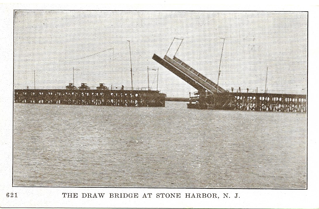
4 – “WHERE THE STEEL SCHERZER ROLLING-LIFT BRIDGE WILL BE ERECTED – This steel bridge, with a span of 50 feet which raises upwards, forms the central, or channel portion of a combined bridge, trestle and abutment structure, aggregating 1,100 feet long (or the distance across Great Channel), as shown in the picture.
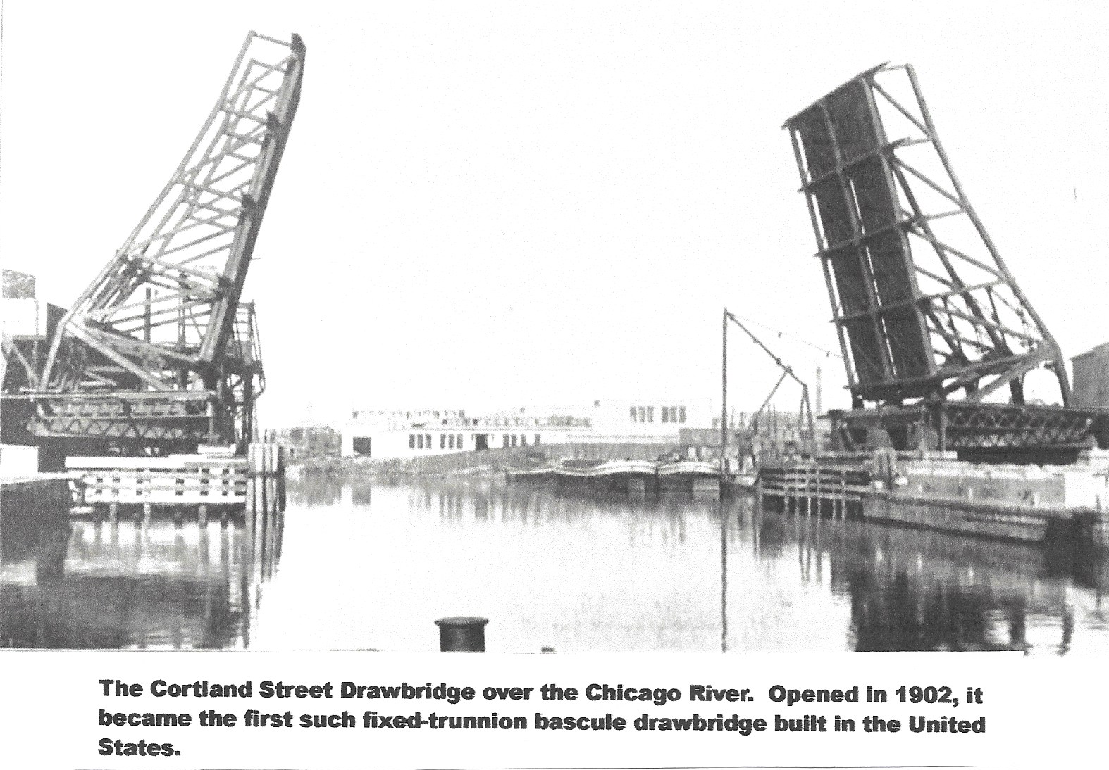
The installing of this type of bridge, used where traffic (both land and water) is likely to be congested, such as over the Chicago River in Chicago
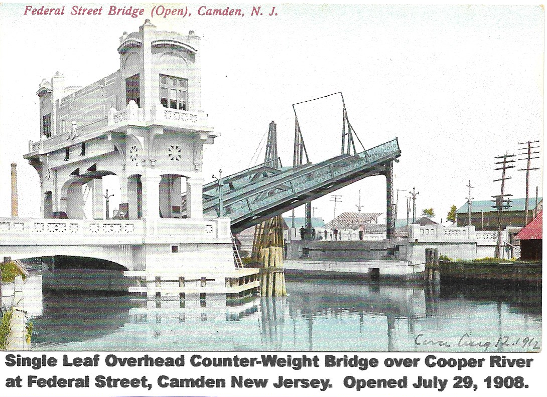
or over Cooper’s Creek in Camden, N. J., marks an innovation along the New Jersey coast as it is the first of its kind, it is believed to be built in the section. It will cause practically no interruption in water-traffic on Great Channel (State Inland Waterway), because it can be opened and closed so speedily that delays should not be of longer duration than three minutes under normal conditions. The draws in common use along the New Jersey coast across inlets and rivers, are chiefly of the trestle swing type, manipulated mostly by hand. The Stone Harbor bridge will be operated by motor power and modernly equipped in every respect.
As an incidental use, the Great Channel bridge will form a great gathering point for visitors to view the yacht races given on Great Channel by the Stone Harbor Yacht Club, whose magnificent home is but a few squares north of the bridge. Fishermen will likewise avail themselves of the structure, as it spans one of the best sections of the Stone Harbor fishing grounds.”
5 – “THE PILE DRIVER AT WORK ON THE BRIDGE – Directly at the foot of 96th Street, can be observed the piledriver which is now busily engaged in driving in pilings for the Easterly abutment of the big bridge and extending the trestle work to beyond the centre of Great Channel where the drawbridge is to be installed. This machine made an interesting trip down the Delaware River and for several miles along the ocean, safely passing into Hereford Inlet and up to Stone Harbor by way of Great Channel, in order to perform the work of driving the piles for the bridge.
The piles, themselves, are heavy pine timbers, creosoted to make them immune from the attack of worms which would otherwise destroy them. Timber, when creosoted, will last for years. The piling, decking and other timbers can be seen below the figures ‘4’ and ‘5’.”
6 – 7 – “ENTRANCE TO THE CAPE MAY COURT HOUSE CANAL. This natural creek or waterway, called Scotch Bonnet, forms the canal entrance almost opposite 96th Street, Stone Harbor. After swinging in a graceful loop to the South Scotch Bonnet turns back into the surveyed line of the great Parkway itself, out where the two hydraulic dredges noted in the picture are located and at which point one of them has excavated the Court House Canal, 100 feet wide and over 10 feet deep in a direct line across the meadows to the far distant mainland shown on the skyline of the picture and to the very gates of the town of Cape May Court House itself.
The effect of the canal is to give to this important county seat town and the county generally, and always-open freight and motor boat waterway to the sea, in which vessels of at least 600 and more tons then can enter and discharge or take on cargoes. Cape May Court House thus becomes a seaport as a result of the work of this Company and its investors.
You will note, across the mouth of Scotch Bonnet (figure ‘7’), a sand-bar which the dredges will shortly remove by pumping the sand out of the mouth of the waterway and canal and forcing it through pipe-lines into the space between the two great sod and dyke retaining walls of the roadway (figure ‘2’).”
8 – “NINETY-SIXTH STREET – This street is the continuation of the Turnpike across the meadows. The bridge is at the end of the street, the right-of-way of the trolley being on the right and Shelter Haven Yacht Basin on the left.”
9 – “THIRD AVENUE – This is designated to be one of the most important streets of Stone Harbor, as it connects all Yacht Basins by the shortest route. Third Avenue is to the channel section what First Avenue is to the ocean side of Stone Harbor.”
10 – “SHELTER HAVEN YACHT BASIN – This magnificent artificial harbor, while but partly shown in this picture, contains 12 acres of water surface and is 40 feet deep in the center, graduating upward in depth toward each side and opening directly on Great Channel, opposite the entrance to the Courthouse Canal. Shelter Haven comprises the largest as well as one of the three (so far entirely completed) out of a chain of seven of these magnificent harbors or basins, all opening directly on Great Channel (State Inland Waterway) and extending along the Stone Harbor side of the channel for over a mile. For the man who wants a bungalow in the Great Channel Colony, where he can keep a motor boat, these basins offer ideal opportunities. As shown in the picture, one can motor, fish, crab or bathe, directly from the door of one’s summer home if desired and at the same time be not over three squares from the magnificent bathing beach and ocean, for which Stone Harbor is justly famous.”
11 – “SOME CHOICE LOTS – This block of lots and the one next to it on the right are particularly desirable because they are situated between the Snug Harbor and between the bridge and Yacht Club with water on three sides of them. The lots in this section are 35 X 110 feet and are given free with 10 Ocean Parkway Construction Bonds, priced $80 each, or $800 for the 10 Bonds and lot. They are being rapidly taken up.”
12 – “GREAT CHANNEL ROUTE OF THE STATE INLAND WATERWAY – This noble salt water river is said to be without an equal in the New Jersey coast, if not on the North Atlantic seaboard. This, an ample waterway 1,100 to 1,500 feet side, sweeping for six miles north and south and forming the back waters of Stone Harbor. On the South, Hereford Inlet pours its turbulent tides, directly from the ocean, into Great Channel; while on the north, the waters from Great Bay, fed constantly from Townsend’s Inlet, combine to keep the broad waters of Great Channel constantly changing with the vigorous daily tide pressures and likewise, filled with all manner of fish. In the Fall and Winter months scores of gunners from all sections of the coast come to Great Channel and the adjoining meadows to shoot mud-hens, ducks, geese and beach birds.”
CONCLUSION: Rarely have I ever seen a single Stone Harbor image that contains such a wide range of essential details and pertinent information as this photo seems to provide. We are fortunate indeed to have access to this highly informative and fragile 112 year old newspaper clipping that is housed at the Stone Harbor Museum. Were it not for such artifacts, we who yearn to learn and know more about the history of Stone Harbor would be seriously hindered.
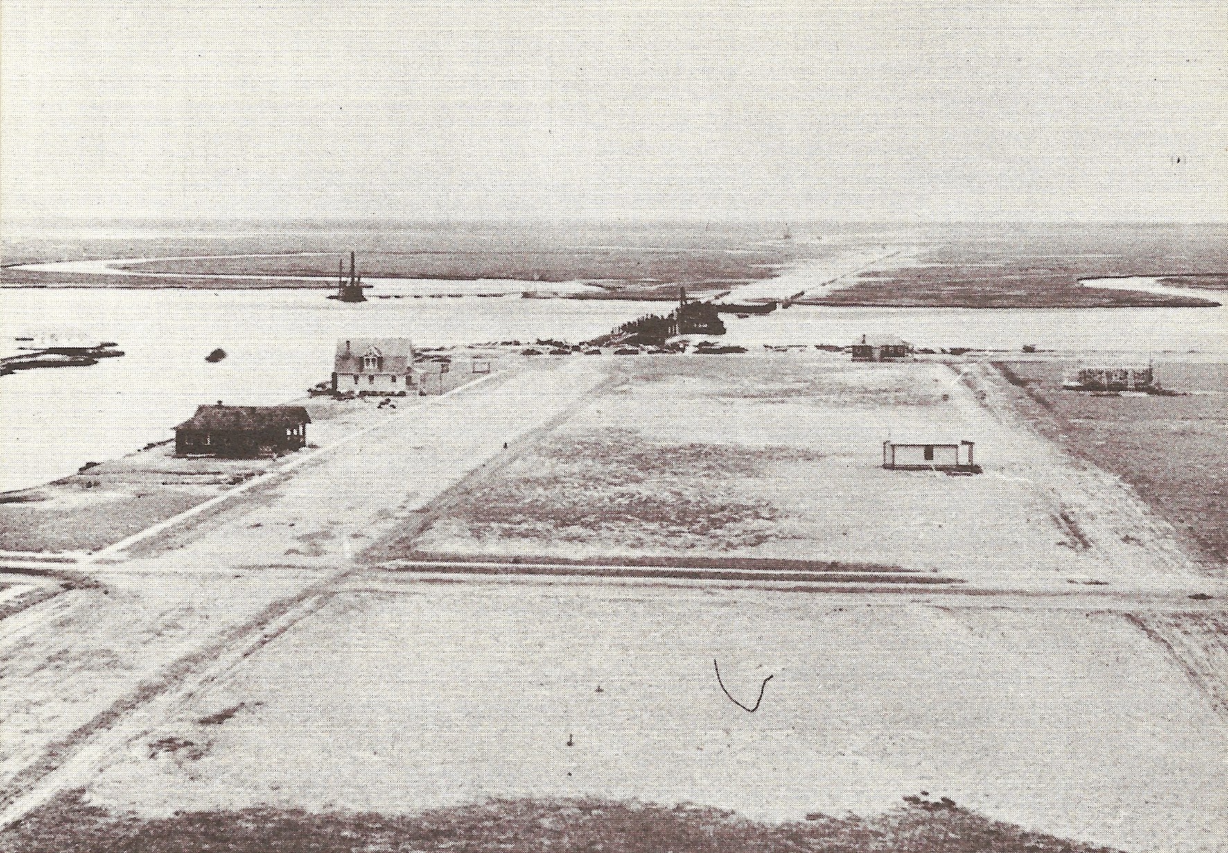
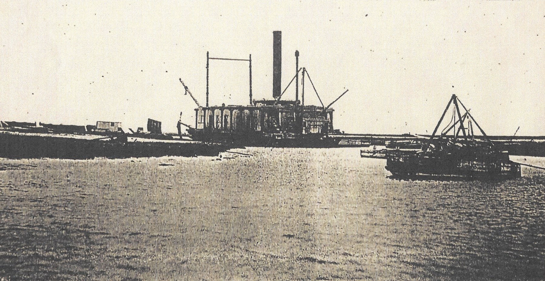
POSTSCRIPT: This final image, also taken in early 1911, was taken shortly after the featured February 1911 photo presented at the outset of this account. While this photo is definitely easier to notice distinguishing details, it is apparent that progress is being made. For example, 96th Street is more discernible and will become a wide thoroughfare for entering Stone Harbor. Also, Third Avenue running from left to right across this image is defined and clearly visible. Continued work on the all important drawbridge is coming along and is evident as well. Lastly, and also visible, the Stone Harbor Ocean Parkway linking the mainland in the distance is being filled in with dredged sand. In just a few months time and by the first week in July of 1911, the Risley brothers will be officially and with great ceremony and fanfare promoting and celebrating a Gala Week of festivities including the opening of the Ocean Parkway and the new bridge into town.
Stone Harbor is now poised to take her place as an up and coming South Jersey seashore resort. Transportation means accessing Stone Harbor along with a water works were provided along with a public school. There were 4 churches, police and fire departments, a beach patrol with life guards as well as a yacht club and even a country club. It would only take less than 3 years when in April of 1914 Stone Harbor would become a full-fledged incorporated borough providing for a Mayor-Council form of government. Following 1914, the first ocean front sea wall or bulkhead was constructed with six wooden jetties. In 1916, Stone Harbor would go on to build a one and one-quarter mile long boardwalk along the ocean front with access to a couple of fishing piers extending out several hundred feet in the ocean. There were now a total of 9 basins, some natural and some man-made, all with protective bulkheads creating more prime real estate. More and more homes were built and businesses to serve the town’s needs also appeared and that essentially summarizes the making of Stone Harbor. Remember, Stone Harbor began with just a vision, a successful marketing strategy and of course with a single important photograph to truly mark the beginning as we have just seen and learned about.
So now I ask you once more the question I originally raised at the outset of this account: “Can you think of a single picture of Stone Harbor that you believe is worth a thousand words?” If so, you just might want to post such a picture on the Meta/Facebook platform for all to see.