
No. 43
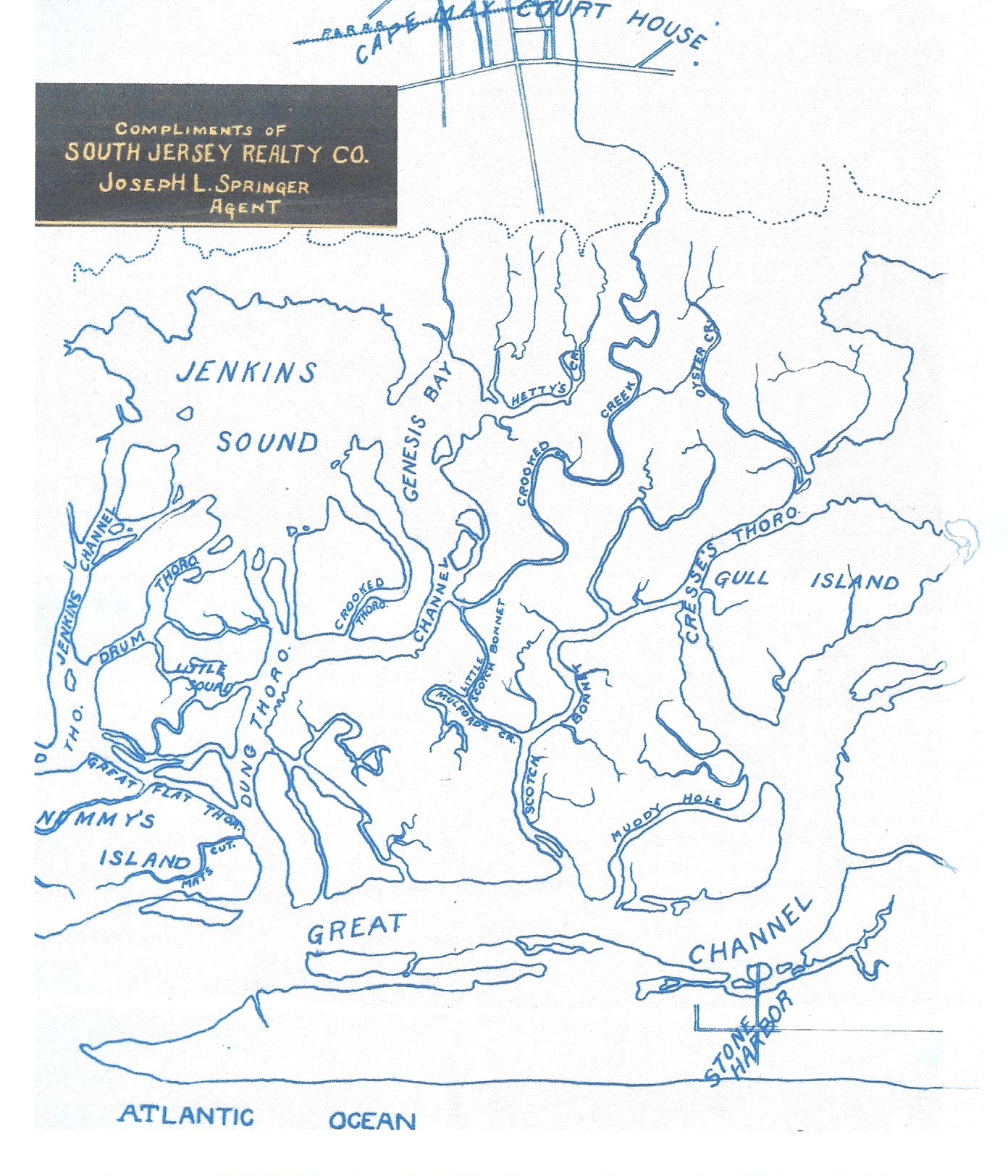
Thanks once again to the Stone Harbor Museum archives, here is an interesting and seldom seen outline map depicting a visual representation of the intricacies of the area of land and water immediately west of Stone Harbor. This rendition expressly prepared by agent Joseph L. Springer of the South Jersey Realty Company demonstrates the real complexities of the salt marshes, sounds, waterways and various islands adjacent to the lower part of Seven Mile barrier island.
Brief Background Information: A bit of historical context needs to be provided to support the outline map shown herein and we will also explain how the map relates to the beginning stages of Stone Harbor’s development.
By the mid-1880s, the barrier island known as Seven Mile Island was the only undeveloped island in Cape May County. That being said, the map illustrated here pre-dates 1911 and shows no evidence of any roadways or railroad links from the mainland to Stone Harbor. In fact, it should be said that aside from the Abbotsford Inn (built in 1892) and about 7 cottages, there really wasn’t much else existing in the original resort before 1910. It is also worth mentioning that noted author and Rutgers University Professor of History Jeffrey M. Dorwart was reported to have said the following about the expansive and intricate area portrayed on the map: “The salt marshes were wider and the channels and thoroughfares more treacherous between this beach and the mainland than for any other barrier island, discouraging travel and delaying development”.
It would not be until the year 1907 when the South Jersey Realty Company, headed by the Philadelphia-based Risley brothers, purchased and acquired the lower-half portion of the island for the hefty sum of $90,000. The 3 enterprising brothers set upon a plan to promote their “New” Stone Harbor as a “high-end” resort utilizing a clever and aggressive campaign to provide the means to link Stone Harbor directly to the mainland and Cape May Court House. A thoroughfare or actually a gravel roadway and bridge were built by the Risley’s in 1911 and in so doing this provided people vital access to the area that was being aptly promoted as “Philadelphia’s Seashore Suburb”.
In order to facilitate the initial stages of development, cottages, streets, curbs, sidewalks as well as public utilities such as electric, sewer and water lines were all being built and put in place. With much of the necessary infrastructure having been installed, 3 basins were dredged creating the North and South Basins at 85th and 90th Streets, followed soon in 1910 with yet another undertaking named the Shelter Haven Basin. Next, and most importantly, some 6 miles of bulkhead were constructed creating many new and very desirable bayside properties on those man-made basins. At the same time an 8,000-foot seawall along the beach side of the resort was built to protect ocean-front properties from storms and water surges. Lastly, vitally important postal, banking and retail operations would need to be provided. When all these many important foregoing features had basically been accomplished, it was then possible to easily access Stone Harbor by auto, train, bus and of course by boat. By 1911-1912 many potential investors were attracted to Stone Harbor and were being incentivized to begin building new homes and even businesses. This influx of people created a growing demand for more goods and needed services.
In closing, one last review of the attached map just in the absence of an aerial photograph might serve as an overview of the area in order to reveal some specific features that some of our readers/viewers are perhaps familiar with including: Nummy Island (a large undeveloped salt marsh between Stone Harbor free bridge to the north and Grassy Sound toll bridge to the south) , Scotch Bonnet Creek Inlet (nearby the hamlets of Stone Harbor Manor and Bennys Landing), the massive Great Channel, Jenkins Sound (situated near the hamlet Bennys Landing and Shellbed Landing) and Gull Island (situated nearby Stone Harbor Manor and Scotch Bonnet). Hopefully you found this account helpful and thereby increased your knowledge of the role that local geography played. Thus the many difficulties and challenges that had to be overcome were all associated with the very early development of Stone Harbor.